Pewter and Charcoal, Giants and the Yorkshire Dales
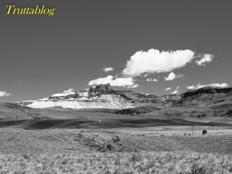
For the most part, the mountains lining the valleys of our upland Trout streams could borrow descriptions from the Dales. But then we have our peaks, which do tower over you as you flick a fly in staircase streams, deep in the berg. The contrast is as rich as the texture of a black and white photo, as polarising as dark shaded ravines cut in a blanket of winter snow.
So here is a contrast: Giants Castle in the snow, and Catlow’s description of the rounded hills of his beloved home waters:

“It is these mountains that bring me back year after year, to the valley through which she flows. They are not the spectacular peaks of the west, thrusting jagged silhouettes defiantly into the sky.They are massive shapes, rising with calm assurance in great sweeps of brown heather, lifting themselves patiently in long and flowing lines, raising their vast bulk to the sky with the huge authority of sufficient strength.”
Laurence Catlow, The Healing Stream
Lessons from the landscape: the 1600m contour
Here in the KZN midlands, altitude is accepted as a defining criteria for Trout water. It has long been held that trout will survive above 1200meters above sea level, and there is very little fishable water above 1800metres. So within that band of 1800m down to 1200m, there are a few critical bands, and I would argue that one of them is the 1600m band. I say that because every listed trout stream in these parts rises above 1600m.
So here is where that contour runs along the front of the Drakensberg:
Interesting isn’t it!
For me what makes it fascinating is that:
- It shows deeply incised valleys where streams cross the line remarkably close to the escarpment
- It shows that ridge of high ground that runs out into the province from the end of Giants Castle to Inhlosane mountain, very clearly
- And from the few spot heights I threw in on the map above, you will see that there are many islands of ground above 1600m, many of which are a long way “from the mountains”.
One also quickly concludes that the altitude alone is a poor measure of where trout thrive. In studying a map in detail, you come to realise that trout will survive and indeed thrive in stretches of river at low altitudes where the valley sides rise to much higher altitudes, and cool short tributaries contribute to the river (Examples, The Inzinga and the Umgeni). Also, if the drainage upstream of where you are standing is overgrazed or densely inhabited, or intensely farmed, then altitude becomes a less significant measure ( Example, The Bushmans below 1400m …below the clinic). Also, if the stream is on a steeply drained area, where the cold fronts coming from the south west are forced up to generate orographic rainfall, the trout are better off. So, for example, south of Giants Castle, the 1600m contour averages about 130 kms from the sea. North of the Hidcote ridge, where the berg tracks north, north-west, the sea is an average of 175 kms from the sea, and over 200kms in many cases. Here it is drier, there are a lot fewer trout streams, and those that there are, have just a short run in the berg before they spill out onto flatter, warmer plains where they don’t hold Trout. In fact, down south (and off below the limits of the map above), we know that in the Ingeli mountain area, trout are found as close as 80km from the sea at altitudes of under 1000m. There the slope from the sea to Ngeli mountain is 25m per km. From a similar altitude on the Mlambonja at Cathedral Peak, to the sea, the slope is under 8m per km. Those southern areas get more life-giving mist and drizzle. Did you ever notice how there are no thorn trees along the N3 from Maritzburg to Hidcote, then on the Estcourt side of Hidcote (the dry side), you can draw a line where the thorns start. Thorns like drier , and/or warmer climates.
Returning to our 1600m contour: At a glance, it is encouraging to see how much land above this contour is in the Drakensberg park, and therefore conserved as catchment area. The exception is where the land juts out from Giants Castle. Parts of that area (top end of Dargle, Inzinga, Fort Nottingham, Western side of Kamberg etc) have at times been threatened by proposed developments. (I hope you will join me at the protests if they try again).
See you in the highlands……above 1600 metres perhaps….
An eagle’s flight over Trout country
If you were to stand on the top of Giants Castle , at the source of the Lotheni and Bushmans rivers, (LINK) and send an eagle in a straight line, at a bearing of 115 degrees, to the top of Inhlosane mountain, the eagle would fly off from your feet at 3100metes above sea level. It would cross the source of the Elandshoek, which peels off to the right (the tributary of the Lotheni that joins the main river opposite the camp site), then it would cross the source of the Ncibidwane flowing away to the North, and on the same side the Mooi, First the north branch and then a tiny highland tarn from which the south branch flows.
Roy Ward hiking out of the Ncibidwana valley. Giants Castle mountain is obscured by cloud in the background.
From that spot the beautiful lakes at Highmoor would be visible, 9kms away to the north east. Just 350 metres past that, to the right is the source of the Inzinga river (altitude 2199 metres), which flows away to the right, and at that spot the Kamberg nature reserve would be a scant 3kms to the north east. The eagle would then cross the very spot where the Reekie Lyn stream rises (a tributary of the Mooi, that joins the river lower down at the NFFC stretch of the same name). After a patch of rocky terrain, the ground would then drop away sharply beneath the eagles wings as it flies over the boundary of the greater Drakensberg heritage site , where the elevation beneath it would be 1800metres ASL, and it would have flown 26kms.
After this half way mark, the rest of the eagle’s journey would be over highland farming country that all hovers around the altitude of 1800m ASL.
It would cross the farm known as “White Rocks”, named after the rocky outcrops still within sight behind it in the park, and it would cross the Lotheni road where the road does that tight sweeping bend to pass over the lovely little Rooidraai stream . This is just before the Rooidraai joins the “Kwamanzamnyama” at that rocky roadside spot where we often see baboons. In summer that stream looks just big enough to hold a few trout, but in winter my belief in that dwindles.
At this point a few farms below will be those that carry the “FP” number, after George Forder who surveyed the Underberg district, and who numbered them so after “Forder Pholela” (Or so everyone thinks: Secretly Forder was using the P in reference to “Plaisance”, a favourite farm name which he would later ascribe to the piece of land at Bulwer that the government of the time gave him for his troubles. I know this because his son told me). Our eagle would then pass just a few hundred yards to the south of “Drinkkop”, that hill which Chris Maloney tells me you can stand upon and pee into the drainages of the Mooi, the Umgeni and the Inzinga all at once.
Just over the crest it would pass directly over Umgeni Vlei (the source of the Umgeni), and then over the ridge and Woodhouse, and several other farms with names of English origin, and a few kilometers on, the land would dip briefly to about 1650m ASL where the eagle would fly directly over a little crumbling concrete causeway over the Poort stream, just above where it tumbles over a hidden waterfall on its way to join the Umgeni. That causeway is a favourite spot of mine. It is on a tiny triangle of land called simply “Fold”.
The causeway is just out of sight beside the parked vehicle in the distance.
The Poort stream on its way down to the Umgeni: The place where my great grandfather is buried, and where my father was born
Looking back towards the Giant from the Heatherdon mast.
It would then pass over Glendoone , and almost straight over the Heatherdon mast (a spot that is precisely 50m lower in altitude than the upcoming final destination of our eagle, just 5 kms away.
From here the dams on Happy Valley, Kilalu, Ivanhoe, Overbury, Lyndhurst, Heatherdon, Kimberley and Rainbow lakes, to mention just a few, would be visible.
From there the land would fall away beneath the flight path quite dramatically for a short spell, where the eagles flight would take it over the Furth Cutting at the precise point where the district road D 710 (which leads to the NFFC water on Furth Farm) takes off from the Mpendle road. The ground would then rise steeply again within seconds as the slope climbs from the homestead on Old Furth to the beacon on top of Inhlosane mountain at 1978metres above sea level, where our eagle would alight after its journey of precisely 51kms.
The eagle will have flown along the spine of high ground that I have written and spoken about before, that pretty much starts at the Giant and ends at Inhlosane mountain. Its eyes would have captured vast vistas of rocky veld with only the occasional pasture or cluster of trees. It would have passed over land that receives regular severe winter frosts, and not infrequently, snowfalls. And I reckon that it would have been able to spot more of the trout waters, both streams and dams, that I have fished in my lifetime, than any other fifty kilometer eagle flight anywhere. It might even have spotted Bernie’s lake!
Looking back at the Giant
I think if I had a chance to rub the magical lamp, that 70 minutes as an eagle would be right up there competing for one of the three wishes.